If you were not at the last meeting, you can submit your nominations here.
Continue readingAuthor Archives: KK4ECR
Pioneer Trail Run Club 5k – 02 October 2021
We will need 6 operators to support the Pioneer Trail Run 5k on 02 Oct 2021. Please complete the form below to register to help out.
Continue readingPioneer Trail Run – September 18
The next Pioneer Trail Run will be held on Saturday September 18. We will report to out posts at 07:00 — this will be an all day run.
Please bring water, snacks, chair. Have spare batteries for your radio. Frequencies will be released as we get closer to the event.
Continue readingTS Elsa Update 05 JUL 2021 17:00
000
WTUS82 KJAX 052128
HLSJAX
FLZ020-021-023-024-030-031-033-035-038-122-124-125-132-133-136>138-140-222-225-232-236-237-240-325-340-425-GAZ162-163-350-364-060530-
TROPICAL STORM ELSA LOCAL STATEMENT ADVISORY NUMBER 22
NATIONAL WEATHER SERVICE JACKSONVILLE FL  AL052021
528 PM EDT MON JUL 5 2021
THIS PRODUCT COVERS NORTHEAST FLORIDA AND SOUTHEAST GEORGIA
**TROPICAL STORM WATCHES EXPANDED ACROSS THE SUWANNEE RIVER VALLEY AND INTO INLAND PORTIONS OF SOUTHEAST GEORGIA**Continue reading
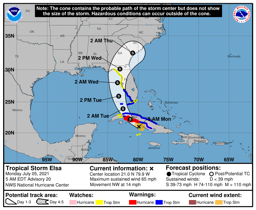
TS Elsa Update 07-05-21
Tropical Storm Elsa
• The center of Elsa is about 225 miles south-southeast of Key West, FL and moving to the northwest at 14 mph
• Elsa remains a tropical storm with maximum sustained winds near 65 mph.
• Elsa is expected to traverse Cuba today and experience some weakening. Late tonight, Elsa will move back over water and head north over the eastern Gulf of Mexico. Little change in strength or some slight re-strengthening is possible after it emerges into the Gulf of Mexico.
• Landfall appears most likely in the eastern Big Bend of Florida. However, the storm will be lopsided with most of the rainfall to the east of the center impacting the entire West Coast as Elsa moves northward.
Florida Outlook:
• Do not focus on the exact forecast points as impacts will extend well outside of the forecast cone.
• Tropical Storm Warnings: Lower and Middle Keys (Dry Tortugas to Craig Key), Mainland Monroe, and coastal portions of Charlotte, Collier, and Lee
• Tropical Storm Watches: Upper Keys (Craig Key to Ocean Reef), Inland portions of Charlotte and Lee, and Citrus, Dixie, Hernando, Hillsborough, Lafayette, Lake, Levy, Manatee, Pasco, Pinellas, Sarasota, Sumter, and Taylor
• Tropical storm force winds from 40-60 mph are possible, particularly in gusts with bands of showers/thunderstorms on Tuesday and Wednesday.
• Storm Surge Watches: Bonita Beach to the Anclote River, or the coastal areas of Charlotte, Citrus, Hernando, Hillsborough, Lee, Levy, Manatee, Pasco, Pinellas, and Sarasota County.
• Storm Surge values of 2-4’ are forecast in the watch area. Storm surge values of 1-2’ are expected across the Keys and Collier County.
• A widespread 3-5” of rain is possible across the eastern Big Bend, Northeast Florida, and West Coast over the next 3 days with localized totals of 6-8”. This could result in some urban or flash flooding early next week due to wet/saturated soils as well as some minor river flooding. Flood Watches may be needed.
• Saturated soils will make trees more susceptible to falling in strong winds.
• Dangerous rip currents are expected at most Florida beaches. Minor to moderate beach erosion is also possible along West Coast beaches with dune overwash.
• There is a threat of isolated tornadoes beginning this afternoon in South Florida and the Keys, spreading up the Peninsula through Tuesday.