
This information copied with permission from Crown Weather Services.
Hurricane Hermine:
5 pm EDT/4 pm CDT Statistics:
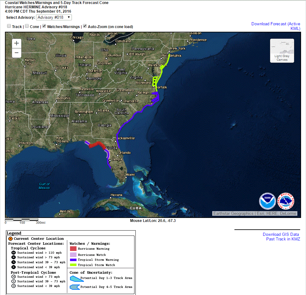
Location: 28.5 North Latitude, 85.0 West Longitude or about 85 miles to the south of Apalachicola, Florida.
Maximum Winds: 75 mph.
Minimum Central Pressure: 988 Millibars or 29.18 Inches.
Forward Movement: North-Northeast at a forward speed of 14 mph.
Current Watches & Warnings In Effect:
Hermine continues to strengthen and it is now a hurricane. The latest reconnaissance flight indicated that the central barometric pressure with Hermine has fallen to 988 millibars and I expect to see this pressure continue to fall the rest of this afternoon into this evening. In addition, radar imagery and satellite loops indicate that there is a closed eyewall with the eye shrinking in size along with building deep thunderstorm activity. This says to me that the hurricane will continue to strengthen right up to landfall. In fact, there is the possibility that it could strengthen to Category 2 strength (100-110 mph) by the time it makes landfall tonight.
I still think that Hermine will make landfall near or just east of Apalachicola (Apalachee Bay) around midnight EDT/11 pm CDT tonight. As for strength at landfall, I’m thinking a upper end Category 1 or a low end Category 2 hurricane with 95 to 105 mph winds or so.
I strongly urge everyone in the Hurricane Warning area to be prepared for 80 to 100 mph winds tonight. Extremely hazardous weather conditions are expected tonight across the Florida Panhandle and northwestern and northern Florida. Winds of up to 100 mph can be expected between 8-9 pm EDT/7-8 pm CDT and 3-4 am EDT/2-3 am CDT tonight in parts of the Hurricane Warning area, especially from Apalachicola through Apalachee Bay to about Cross City. Be prepared for widespread downed trees and power outages that could last for up to one week or more across the Hurricane Warning area.
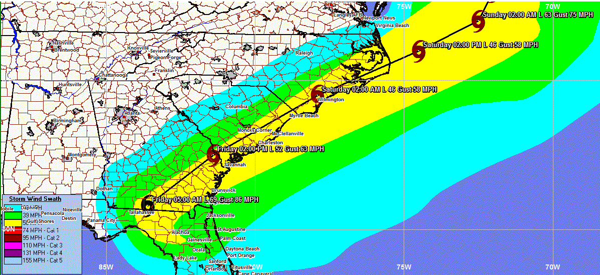
After Hermine makes landfall tonight, it will then spread a swath of 50-80 mph wind gusts across inland portions of the eastern Florida Panhandle, including Tallahassee, northwestern Florida and southern Georgia from late tonight into Friday morning. Downed trees and power outages that could last for up to one week are also possible across inland parts of the eastern Florida Panhandle, including Tallahassee, northwestern Florida and southern Georgia.
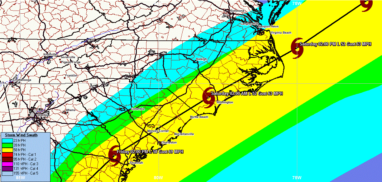
Hermine is then expected to move across eastern Georgia and eastern South Carolina on Friday and Friday night and then exit back into the Atlantic around southeastern and eastern North Carolina on Saturday morning.
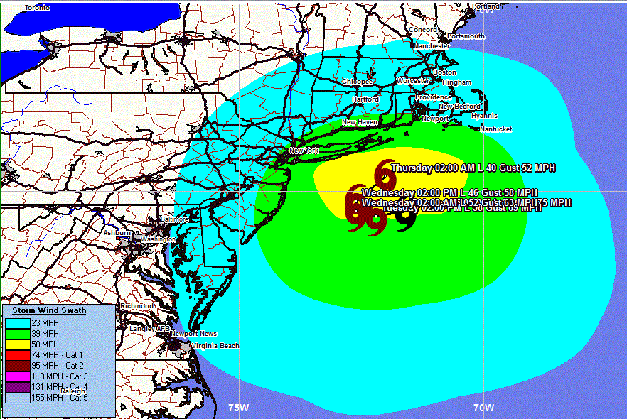
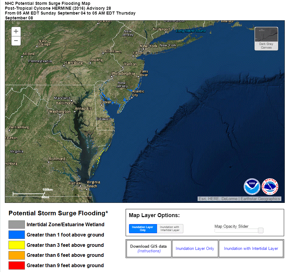
Beyond this, it still looks like a very stormy Labor Day weekend is in store for eastern North Carolina, eastern and southeastern Virginia, the DelMarVa Peninsula, the Jersey Shore, Long Island, the South Coast of New England, Cape Cod and Nantucket as it is expected that Hermine will slow way down in forward speed and stall somewhere between the Delmarva Peninsula and Long Island from Sunday to possibly as long as Wednesday as it is blocked from moving anywhere by a strong ridge of high pressure that is forecast to stretch from northern New England southeastward to the western Atlantic.
This means that a prolonged period of heavy rainfall, strong onshore winds of 40-50 mph and a pounding surf that leads to coastal flooding along much of the coastline from Cape Cod and the south coast of New England southward to Long Island and the New Jersey coastline to much of the Mid-Atlantic coastline that lasts from Saturday to perhaps as long as Tuesday or Wednesday.
I want to stress that I continue to have serious concerns about a significant impact along much of the Mid-Atlantic coastline as well as across parts of southeastern New England and the south coast of New England. If you live or have interests anywhere across the Mid-Atlantic States or in southern New England, please pay very close attention to the progress of Hermine as it could bring significant impacts to you this weekend into part of next week.
Forecast Impacts From Hermine:
Rainfall:

Winds: Hurricane force winds are expected across the Florida Panhandle and northwest Florida starting this evening and continuing through the overnight hours of tonight. Winds of up to 100 mph are expected between 8-9 pm EDT/7-8 pm CDT and 3-4 am EDT/2-3 am CDT tonight across the eastern Florida Panhandle and northwestern Florida tonight. Be prepared for widespread downed trees and power outages that could last for up to one week or more across the Hurricane Warning area.
Tropical storm force winds with wind gusts of 50-80 mph are expected to overspread the rest of northern and northeast Florida as well as southern and eastern Georgia by later tonight and continue through Friday.
Across eastern South Carolina and eastern North Carolina, tropical storm conditions are expected from Friday afternoon through Friday night into Saturday.
Tropical storm conditions are possible from Saturday to Tuesday from eastern and southeastern Virginia northward through southern and eastern New Jersey, Long Island, the south coast of New England and Cape Cod from Saturday to Monday.
Forecast Wind Swath Map:
Storm Surge: Life-threatening storm surge flooding is expected tonight along the Gulf Coast of Florida from Indian Pass to Long Boat Key, including the entire coastline around Apalachee Bay.
If you live in this area and are prone to storm surge flooding, be prepared to take all necessary actions to protect life and property from rising water. Promptly follow any evacuation instructions from local officials.
Forecast Storm Surge Tonight:
Tornado Threat: A few tornadoes are expected tonight into Friday morning over northern and central Florida and southern and eastern Georgia. The tornado risk will spread into eastern South Carolina and eastern North Carolina during Friday and Friday night.

Model Track Forecast For Hermine:

![]()
![]()
![]()
Model Intensity Forecast For Hermine:
![]()
Satellite Imagery Of Hermine:


Radar Imagery:


